
Record Solar Irradiance Swings Hit Asia as Typhoons Surge
El Niño intensification points to sustained solar generation divides between Southeast Asia and northern markets through December.
A strengthening El Niño is redrawing the solar energy map across Asia, splitting the continent into zones of record-breaking sunshine and historically low irradiance as the final quarter of 2026 begins. For operators managing the region’s rapidly expanding photovoltaic fleets, the volatility that defined September signals a shift in power generation patterns that will persist through December.
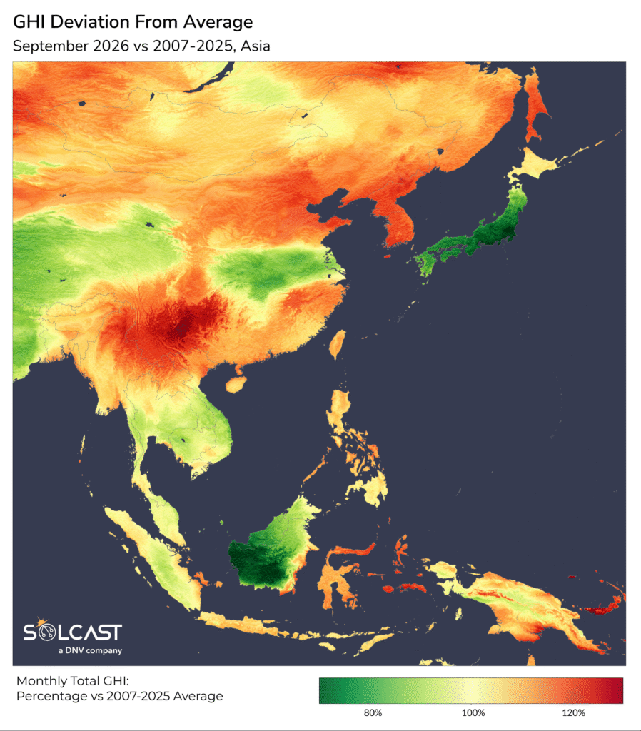
Southern China’s Yunnan-Guizhou Plateau recorded the sharpest solar anomaly on the continent last month, with irradiance surging to 30% above normal. The Philippines, the Korean Peninsula, and eastern Indonesia also posted substantial gains, landing in the highest historical quintile for September when compared against multi-year records. These spikes translate directly into unexpected generation surpluses for grid operators in Manila, Seoul, and Jakarta, complicating load balancing at a time when regional electricity demand remains high.
The surplus in those markets stands in stark contrast to conditions in Japan and Borneo, where solar exposure collapsed to roughly 70% of typical September levels. Both regions registered their lowest September irradiance on record.


Borneo’s deficit was driven by a two-part atmospheric event. Wildfire smoke initially choked the island’s skies before denser cloud cover took over later in the month. Transboundary haze from agricultural burning on Sumatra and Kalimantan has long plagued Southeast Asia, but its intersection with shifting tropical weather patterns created an unusually prolonged suppression of solar radiation.
Japan’s shortfall stemmed almost entirely from a relentless sequence of tropical cyclones fueled by extreme sea surface temperatures in the western Pacific. Typhoons Dujuan and Surigae struck the Japanese archipelago in rapid succession, while Typhoon Choi-wan added further disruption. Between Sept. 20 and Sept. 23, multiple storm systems occupied the Pacific basin simultaneously. Lesser tropical depressions dragged heavy cloud bands across Vietnam and Thailand, compounding the regional dimming effect.
The 2026 Pacific typhoon season has outpaced historical averages largely because ocean heat content provides more thermal energy for storm intensification. Warmer waters lower the threshold for cyclogenesis, allowing storms to organize faster and maintain strength longer, which expands the geographic footprint of their associated cloud canopies.
This same oceanic heat engine is now driving El Niño metrics toward record territory. The climate pattern’s continued intensification is the primary variable shaping the October-through-December solar forecast. Meteorological models show strong consensus that El Niño will push sunnier-than-average conditions deeper into Southeast Asia over the next three months. Conversely, eastern China and Japan are projected to face persistent cloud cover, extending the generation deficits they experienced last month. Forecasts for South and Central Asia remain mixed.
For the global solar industry, these continental-scale swings carry immediate financial weight. Accurate irradiance tracking has become critical infrastructure for energy trading, asset valuation, and grid stability. Companies currently rely on satellite-derived data processed through machine learning algorithms operating at 1-to-2-kilometer resolution to model these shifts. Solcast, which supplies this telemetry to firms managing more than 350 gigawatts of solar assets worldwide, reports its models typically maintain a bias below 2%.
Oceanic monitoring stations confirmed this week that the current El Niño episode continues to track near the upper bounds of historical intensity thresholds heading into the Northern Hemisphere winter.