

Extreme Gironde Fire Spawns Rare Firestorm Cloud in Unprecedented European Heat Event
A massive forest fire in southwest France generated a pyrocumulonimbus storm, producing lightning strikes and volatile winds that drove flames across 420 square kilometers.
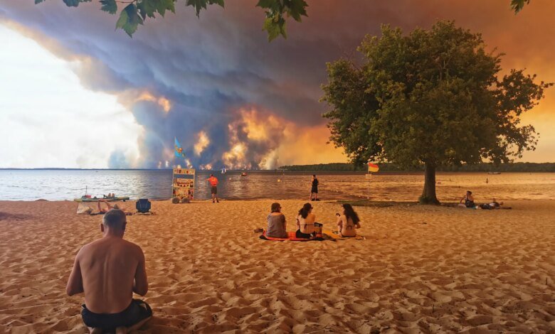
A massive forest fire in southwestern France has crossed a critical meteorological threshold, becoming powerful enough to generate its own localized thunderstorm system, emergency services and atmospheric scientists reported.
The outbreak, which ignited on July 22 near the municipality of Saumos in the Gironde department, expanded rapidly across pine forests and dry scrubland. By the second day of the blaze, intense heat currents forced superheated air, ash, and moisture high into the atmosphere, forming an electrified pyrocumulonimbus cloud—a rare phenomenon colloquially known as a pyroCb or firestorm cloud.
France’s national firefighters federation stated that a pyrocumulonimbus event had never before been officially documented in the country. The cloud system generated cloud-to-ground lightning strikes that ignited secondary fires well beyond the primary fire perimeter, while generating sudden, multi-directional wind gusts that severely hindered suppression operations.
To date, the Gironde wildfire has scorched more than 420 square kilometers (162 square miles), destroyed or damaged over 240 structures, and necessitated the evacuation of roughly 220,000 residents across the region.
Pyrocumulonimbus formations represent an extreme manifestation of fire behavior. When intense surface heat creates a powerful updraft, smoke particles act as condensation nuclei for water vapor. As the rising plume penetrates colder atmospheric layers, supercooled water droplets freeze into ice crystals. Collisions between these ice particles build high electrical charges that eventually discharge as lightning.
“Imagine a campfire so large and hot that the smoke rising off it turns into a storm-like cloud,” explained Theodore M. Giannaros, a fire meteorologist at the National Observatory of Athens. “Once it forms, the cloud becomes its own weather system, sitting on top of the fire and making it harder to predict.”
Giannaros noted that pyroCb clouds depend on atmospheric conditions prone to dry thunderstorms—specifically, intense low-level heat and dryness paired with cooler, moister air aloft. The resulting atmospheric instability creates violent feedback loops. Downdrafts from the storm cloud punch back down toward the ground, fanning flames in unpredictable directions and occasionally generating fire whirls—vortexes of flame and heated air that can collapse containment lines in seconds.
Historically, pyrocumulonimbus clouds have been observed almost exclusively in vast, highly flammable landscapes in North America and Australia. In 2023, record-breaking Canadian heatwaves triggered 142 separate pyroCb events. By contrast, European occurrences remain exceptionally rare, with Portugal recording a major instance during its devastating 2017 wildfire season.
The emergence of such extreme atmospheric behavior in Western Europe coincides with accelerating climatic shifts across the continent. Europe is warming at approximately twice the global average rate since the 1980s, according to joint monitoring by the Copernicus Climate Change Service and the World Meteorological Organization. Prolonged heatwaves and persistent soil moisture deficits have progressively turned southern and western European forests into highly volatile fuel beds.
European scientific initiatives, including the ROSETTA research project, are working to analyze these emerging fire-weather dynamics as extreme events move into regions without historical precedent. For emergency crews on the ground, the formation of a pyroCb fundamentally shifts operations from direct fire suppression to defensive perimeter protection, as erratic winds and distant lightning strikes outpace conventional evacuation and firefighting capabilities.