

Strongest El Niño Since 1950? NOAA Sees Record Ocean Heat
Ocean Heat Surge Drives Historic Winter Forecast
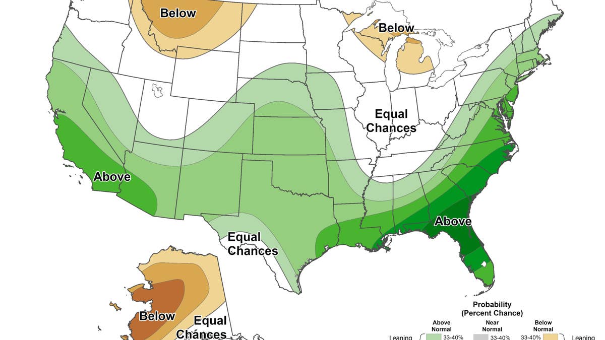
Ocean temperatures in the eastern equatorial Pacific have climbed more than 4 degrees Celsius above normal, prompting the National Oceanic and Atmospheric Administration to assign an 83 percent probability that this winter’s El Niño will exceed any recorded since 1950. This surge in sea surface heat, far stronger than models predicted just weeks ago, fundamentally alters the atmospheric dynamics governing North American weather patterns.
The Climate Prediction Center now forecasts a strong to very strong event persisting through March. Meteorologists attribute the rapid intensification to record-warm oceans, which inject extra moisture into storm systems tracking along a shifted jet stream. While many northern states face below-normal snowfall, the thermal energy stored in the Pacific creates a volatile environment for extreme precipitation events.
Which States Could Face Heavy Snow This Winter

National Weather Service director Ken Graham explained that the intensified El Niño forces the jet stream southward and eastward. Storms follow this track, pulling moisture from the warm waters. The most significant snow signal appears over the southern Rockies, where the combination of cold air masses and abundant water vapor could produce unusual accumulation. James Belanger of The Weather Company identified this region as the likely location for a white Christmas.


Regional outlooks diverge sharply. Arizona and New Mexico hold 40 to 50 percent odds for above-normal precipitation with no clear temperature anomaly. Colorado and southern Utah show weaker signals at 33 to 40 percent, though AccuWeather projects Denver will see 10 to 18 days with at least two inches of snow, nearly double its historical average of nine. Salt Lake City stands out as the only major metro area expected to exceed normal snow totals. Oklahoma and northern Texas mirror the Southwest’s wet potential under neutral temperature conditions.
In the Southeast, the cooler, wetter pattern sets the stage for mixed precipitation. When Arctic air collides with these energized storms, sleet and freezing rain become probable. CNN reported that this dynamic increases the risk of hazardous travel conditions across the lower East Coast.
How The Outlook Has Shifted Since September
Confidence in the event’s strength has grown rapidly. In early September, the Climate Prediction Center estimated a 69 percent chance of a historic El Niño. That figure jumped to 83 percent by mid-October. Simultaneously, ocean temperatures rose from 3 degrees Celsius above average to over 4. The projected wet zone also expanded; September maps showed a 60 percent chance of excess rainfall in parts of the Southeast, while December-through-February forecasts now indicate 70 to 80 percent probabilities over southern Georgia and northern Florida. The next update arrives November 19.
East Coast Storm Risk
Major Northeast cities face a paradox. AccuWeather expects Chicago, Boston, New York, and Philadelphia to receive half or less of their typical winter snowpack. However, Jon Gottschalck of the Climate Prediction Center warned that some southern storms may curve northeast along the coast. If cold air is entrenched, these systems can dump heavy rain and snow on Mid-Atlantic and Northeast hubs. “These storms could be very strong,” he said.
Paul Pastelok, lead long-range forecaster at AccuWeather, pinpointed late January and February as critical windows. “It only takes one storm to flip the script, especially for the East Coast cities,” Pastelok noted, highlighting how a single intense low-pressure system can overwhelm seasonal averages.
What It Means For Drivers
Seasonal maps provide probabilistic guidance, not trip-specific warnings. Milder winters do not eliminate blizzard risks. “It doesn’t erase the risk,” Graham stated. To address severe outliers, the National Weather Service has introduced “Particularly Dangerous Situation” language for select Blizzard and Ice Storm Warnings this season. This designation applies only when forecasters possess high confidence in events of historic severity, signaling immediate threats to life and property.