
Amazon Drone Delivery in Nampa Is Live. The Neighbors Below Never Ordered Anything.
The drones fly out of a warehouse on Franklin Road and drop packages from about 12 feet. The people underneath them did not place an order, did not sign a form, and cannot opt out of the overflight.
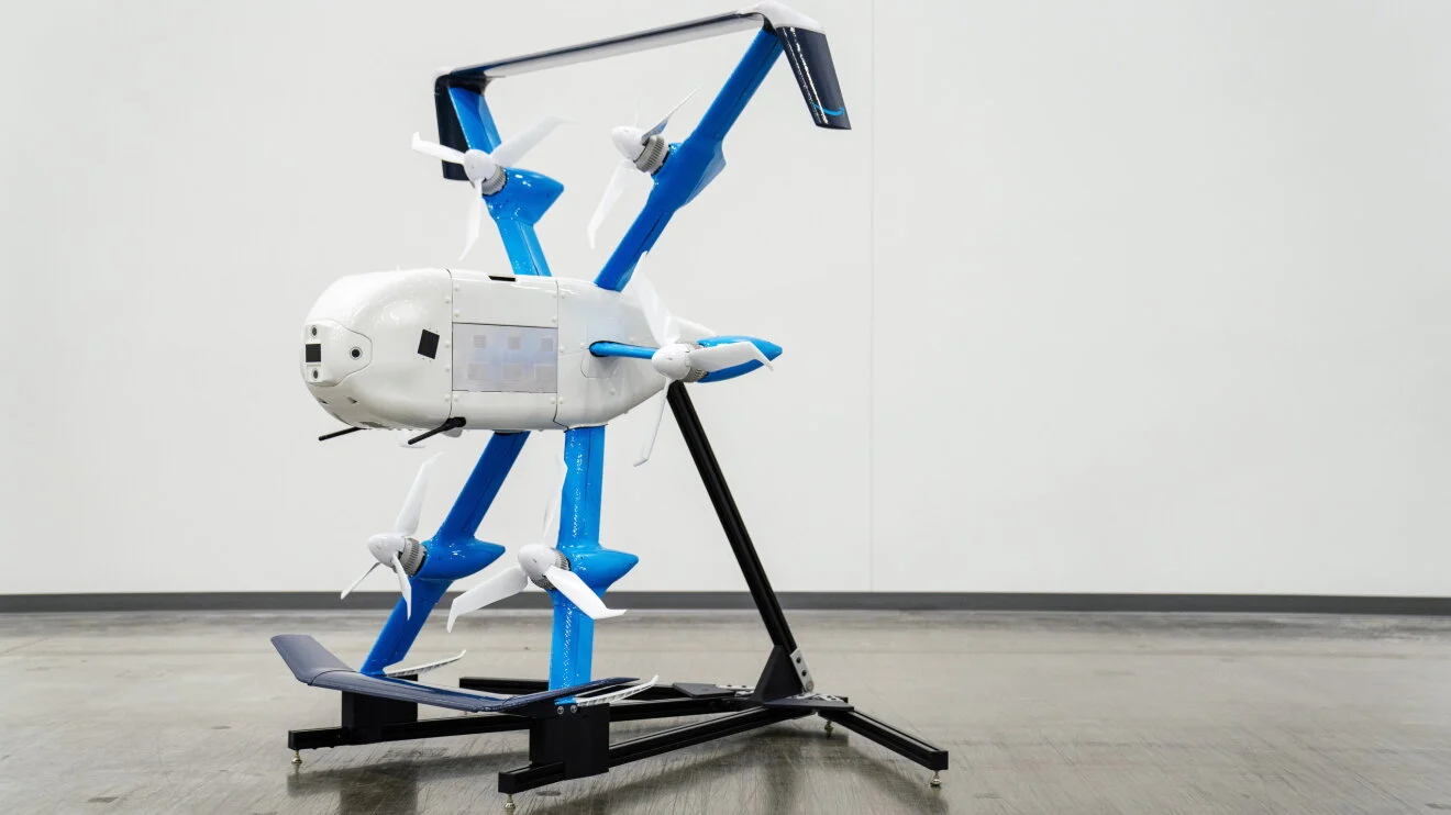
Erica Ewing saw one come down on Linder, in Nampa, and drop a package in a side yard next to the sidewalk. “I saw one today and it dropped a package on the people’s sideyard, on Linder, right next to the sidewalk,” she wrote in a comment on KIDO Talk Radio’s Facebook post. “My first thought was somebody is going to pick that up.”
Amazon drone delivery in Nampa went live in the last days of October, the first city in Idaho to get the service. The drones fly out of Amazon’s fulfillment center on East Franklin Road and reach about 7.5 miles, which takes in parts of Nampa, Meridian, Star, Middleton, Kuna, and Boise. The aircraft is the MK30, about 83 pounds at takeoff carrying a package of up to 5 pounds, and it lowers the box from roughly 12 feet instead of landing. Flights run every day from 30 minutes before sunrise to 30 minutes after sunset. A delivery costs $4.99, or $2.99 for Prime members, and is free on Prime orders of $50 or more, with arrival in as little as 30 minutes.
Shana Aitkins White wrote that her children had already seen one on their street. “My kids have already seen it on our street. Not a fan.” Roxane Eileen Meier keeps a small table where her packages are delivered, and she worried about what happens when a drop lands somewhere else in the yard. “I have a little table where my packages are delivered. My concern is that if they are dropped on the lawn somewhere else that my dog’s going to get to it and chew it up,” she wrote on Facebook. “It could be the animal getting sick or injured.”
Gina Johnson asked the question first, in May, at a community meeting at the College of Western Idaho, before the Planning and Zoning Commission voted. Johnson, a Meridian resident, wanted to know how the drones would track whether a person was at a delivery point. “How are they gonna track you that you’re there?” she asked, according to Idaho News 6 reporting quoted by DroneXL. She asked what contract she would have to sign, and what the liability would be if she was not there. Sam Bailey, Amazon’s senior manager for economic development, was questioned for about an hour on noise, safety, and logistics, and residents who opposed the service raised bird safety among their objections. The board then voted unanimously to approve a 21,000-square-foot drone hub on the edge of the existing fulfillment center parking lot, giving up 114 parking spaces and adding about 30 jobs.
Bailey told Reuters the drones would be audible for about 20 seconds while descending and then flying away, at a noise level lower than a lawnmower. “It’s a brief experience,” he said. Amazon told Reuters that community concerns over privacy were unfounded, and that the embedded cameras are used only for navigation.
The description on Amazon’s Prime Air Drone Delivery Operations page, as DroneXL quoted it on September 28, says the cameras may record people, pets, cars, and objects near a delivery or landing location, and that Amazon uses the images to improve drone delivery and other Amazon services. The page offers an opt-out at a household’s own address, and none for a neighbor’s address. Amazon spokeswoman Lindsay Hamilton told the New York Times in September that the images sit on encrypted drives that only authorized staff can access, for safety and customer service. Bailey gave the narrowest version of the description to the Pflugerville, Texas, council on September 22, telling members the drones “can’t scan faces, look at license plates, or take pictures or images,” according to Community Impact reporting quoted by DroneXL. The three descriptions can all be true only if taking pictures means something narrower than recording, and Bailey did not draw that line for either council. DroneXL checked the page again on October 6 and found the same language there.
Section 21-213 of the Idaho Code governs the use of unmanned aircraft systems in the state, and its wording turns on two words. Section 21-213 of the Idaho Code says no person, entity, or state agency shall use an unmanned aircraft system to intentionally conduct surveillance of, gather evidence or collect information about, or photographically or electronically record specifically targeted persons or specifically targeted private property, including a dwelling and its curtilage, without written consent. A person subjected to prohibited conduct has a civil cause of action for the greater of $1,000 or actual and general damages, plus attorney’s fees. Nothing in the section addresses a neighbor caught in the frame of someone else’s delivery, a recording that was not aimed at them, or images kept afterward. The section also bars recording an individual without consent for the purpose of publishing or publicly disseminating the recording.
In 1946, the Supreme Court heard a chicken farmer’s complaint about low-flying military aircraft over his land near Greensboro, North Carolina. In United States v. Causby, decided in 1946, military aircraft flew as low as 83 feet over Thomas Lee Causby’s chicken farm near Greensboro, North Carolina, 67 feet above his house and 18 feet above his highest tree, and the noise and glare destroyed the farm’s use. The Supreme Court held that flights so low and so frequent as to directly and immediately interfere with the use and enjoyment of land amount to a taking, and Justice William O. Douglas wrote that a landowner “must have exclusive control of the immediate reaches of the enveloping atmosphere” to have full enjoyment of the land. The airspace above the minimum safe altitudes of flight, the Court said, is a public highway. The MK30 cruises at roughly 180 to 377 feet in the Federal Aviation Administration filings for its delivery areas, above the 83 feet in Causby’s case and below the 500-foot daytime minimum the Court was working with then. The opinion set no altitude at which a landowner’s control ends.
The federal decision that cleared the way for Nampa was signed on July 28, 2026, when the Federal Aviation Administration issued a nationwide programmatic environmental assessment and a finding of no significant impact for drone package delivery under Part 135, replacing the market-by-market assessments the Federal Aviation Administration had conducted for each expansion since November 2021. On September 28, fifteen states and Harris County, Texas, petitioned the United States Court of Appeals for the Second Circuit to set that finding aside, arguing it did not adequately address safety risks and other environmental impacts. Idaho was not among the states that filed. No Nampa-named environmental document has surfaced in the public record, and the same federal index that listed Chicago’s assessment as a draft in October carries no Idaho entry this article could find. Four members of the Massachusetts congressional delegation asked the FAA on October 14 for a site-specific assessment of Amazon’s proposed Westborough hub, with a public comment period, before operations begin there.
Richardson, Texas, has lived with the drones since December 2025, and its residents started counting them. Stephanie Puri, a resident there, set up a tracker and logged 52 Amazon drones over her yard on Friday, September 18, and told the New York Times it was a slow day. Amazon told the paper that fewer than 1 percent of inquiries about the program this year concerned noise. After a March council hearing in Richardson, Bailey told council members Amazon had changed the drones’ average flight height and made tweaks to routes to fly over commercial zones more consistently. In Westborough, Massachusetts, Amazon’s Tareq Wafaie told residents there is no opting out of drones flying over their property.
“I’m in Nampa and have ZEEERRROOO problems with it,” Joe Cockrell wrote on Facebook. Leanne Moselle, writing on the same post, asked why people upset about Flock license-plate cameras were quiet about cameras flying over yards. The official account in Nampa describes a delivery service for the person who ordered. The comments describe a neighborhood learning what it is like to live under it without ordering. Pflugerville’s council had voted on August 25 not to renew its Flock Safety contract after learning that outside agencies had searched the city’s plate data nearly 1.6 million times in six months.
Nampa Municipal Airport, a general-aviation field owned and operated by the city, sits about two miles in a straight line from the Franklin Road fulfillment center, measured between the two addresses. The airport’s own business plan describes it as 1.5 miles northeast of the Nampa city center, close to housing, with no significant noise complaint issues at the time the plan was written.