

At 4,864 Metres, Tibet’s 7.0 Earthquake Rescue Is a Fight Against the Plateau Itself
The quake struck Baqen county at 10:33 p.m. local time — and the rescue operation now underway at 4,864 metres has to cross closed highways, suspended rail lines and a snowfall forecast to reach it.

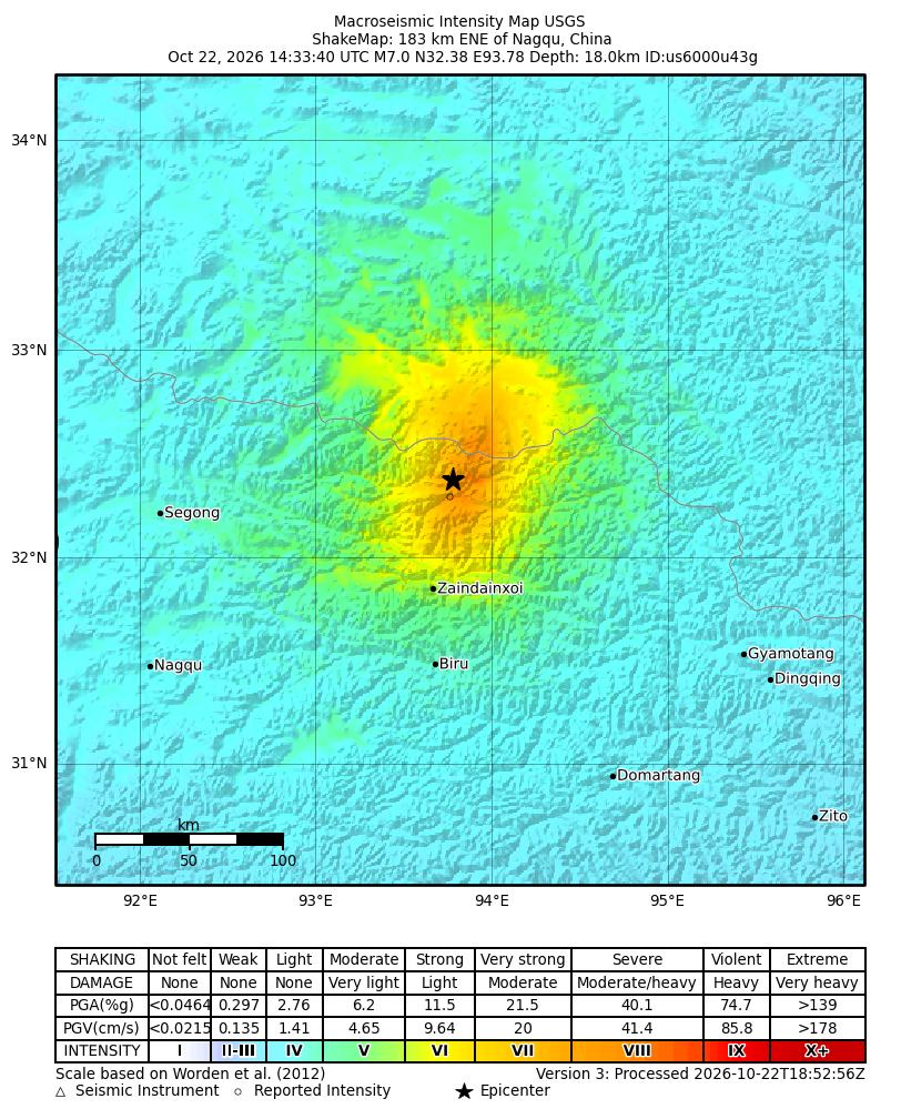
The earthquake struck at 10:33 p.m. on Thursday, at an elevation where each breath carries about half the oxygen it would at sea level. It measured magnitude 7.0, the strongest to hit China since January 2024, with its epicenter in Maru township, Baqen county, about 191 kilometres east-northeast of Nagqu and 390 from Lhasa, the US Geological Survey said. The China Earthquake Networks Center put the average elevation within five kilometres of the epicenter at 4,864 metres.
By 5:20 a.m. Friday, the Nagqu emergency management bureau had counted 16 dead and 46 injured, 11 of them seriously. It was the second tally of the night: house-to-house checks had pushed the injured figure up from 32. At least 339 homes collapsed, and 20 livestock sheds. The 5:20 a.m. figure followed another round of house-to-house checks, and the checks were still going.
Around midnight, the Western Theater Command’s Air Force sent an unmanned aircraft over the zone to send back live imagery, the command said in a statement published by China News Service. On the ground, the Tibet Military District and the Armed Police Tibet Corps pushed more than 300 officers and soldiers onto the roads overnight with over 20 vehicles, and by about 3 a.m. troops from the Nagqu sub-district reached Zharuogai, a village in Maru township. They walked the collapsed houses, put up tents on the spot, and opened a temporary meal point. The Armed Police Nagqu detachment followed with breaking and search-and-rescue equipment and began clearing the access routes. Maru’s deputy township head, Lhawang Dagpo, told Xinhua the shaking was clearly felt at the township office, whose walls cracked.


Baqen’s county seat, some 70 kilometres from Maru, lost power and telecommunications in the quake. Rockfalls closed sections of National Highway 317, denting a car and the guardrails, and local rail services were suspended. Intermittent snowfall is forecast over the coming days.
The relief list released at 4:30 a.m. reads like a description of the weather: 1,000 prefabricated housing units, 3,239 tents, 2,821 folding beds, 4,280 quilts, 200 stoves, 100 mattresses, 2,000 sets of cotton clothing, 1,760 military overcoats, four generators, 1,000 flashlights and 1,000 head lamps, drawn from national, regional, city and county stores. Another 347 firefighters from the regional rescue corps and more than 300 police officers were sent to the epicenter area, and the county’s own authorities put over 1,600 people into the effort.
At least 339 homes came down against about 16 dead. The USGS estimates only around 10,000 people were exposed to strong shaking — the villages nearest the epicenter, Lengda, Puqin and Gaijia Ka, are scattered thin across a near-empty plateau, so there were few people inside the buildings that fell. The Tingri quake of January 2025, which hit denser villages, killed 126.
Baqen had rehearsed for this, at least on paper. The county ran comprehensive earthquake emergency drills in May 2026 and evacuation exercises in townships including Ya’an that September.
The instruments disagree on one measurement. CENC put the quake’s depth at 10 kilometres; the USGS says 18. The USGS’s rupture model gives the fault at roughly 50 kilometres long by 20 deep — normal faulting, the plateau stretching under its own weight. The ShakeMap’s third version was processed at 18:52 UTC on Oct 22, four hours after the ground moved.