

Why Is Pagosa Springs Flooding Again Before the Last Flood Was Repaired?
The forecast climbed from 9.5 feet to more than 21 feet in three days, while the town was still counting the damage from October 23 and the unpaid repairs from October 2025.
The Town of Pagosa Springs updated its flood page at 5:25 p.m. local time on Sunday with the order residents had been waiting for all weekend and the number that kept changing. The San Juan River could crest as high as 19.71 feet, or higher, around 11 p.m. that night. Everyone in the evacuation zones along the San Juan, Rio Blanco, Navajo and Piedra rivers had to leave immediately, the town said, and rescue operations might be severely limited during the worst of the storm. Highway 160 had been closed to traffic coming into Pagosa Springs since 2 p.m., with no re-entry until officials said it was safe. The Pagosa Springs flooding that began on October 21 had already forced one evacuation; this was the second in ten days, ordered while damage from the first was still being assessed and the repairs from the year before were still unfinished.
On Thursday, the National Weather Service projected the river would reach 9.51 feet on Monday morning, barely above its 9.48-foot action stage. By Friday afternoon the Archuleta County Sheriff’s Office was telling residents to expect a crest of 10.58 feet, just over minor flood stage. At an emergency meeting on Saturday morning, Town Manager David Harris told KSUT public radio that the Weather Service expected 17 feet early Monday, and added, “Last week the river peaked at 15 feet.” The county’s 8 p.m. update on Saturday put the crest at 16.9 feet around midnight on Sunday. That night the Weather Service revised it to nearly 20 feet. A National Oceanic and Atmospheric Administration hydrograph issued at 7:51 a.m. on Sunday forecast 19.38 feet. By Sunday afternoon a Weather Service graphic showed a forecast peak of 21.87 feet, and Colorado Public Radio reported 22 feet for Sunday evening, while the town’s own 5:25 p.m. update held at 19.71 feet or higher. In three days the forecast had climbed more than 12 feet, and the two latest official figures disagreed by about two feet.
Between Wednesday and Friday of the previous week, the river rose about 9.5 feet in 34 hours and crested at 15.02 feet at 5:30 a.m. on Friday, October 23, the second-highest level on record. County Commissioner Warren Brown told a residents’ meeting the following Tuesday that about 800 structures had been affected, including about 540 homes. The Colorado Incident Management Team carried out about 40 rescue missions, recording 325 contacts with homes, vehicles and people in the field, and led 38 stranded people out. The Colorado National Guard had rescued 33 people and more than 15 pets by October 27, according to the governor’s office. About a quarter of the county’s roads were still impassable the following Tuesday. Governor Jared Polis declared a disaster emergency covering 12 counties on October 23. No deaths or injuries were reported in Archuleta County at the Tuesday meeting.


The forecast for this weekend was one to three inches of rain across southern Colorado, against two to five inches the week before, with more than seven inches in some places. The Weather Service said on Thursday that it did not expect flooding as widespread as the last event. What changed was the ground the rain fell on and the form it took. The ground was saturated, Colorado Public Radio reported, with little capacity left to absorb rain. State public information officer Niki Carpenter said the last storm had delivered snow at higher elevations while this one was warmer, so rain would fall and snow would melt into the same rivers, and floodwater could reach beyond where it went the week before. A Weather Service meteorologist told the Durango Herald that rain, not the expected snow, was falling as high as 11,000 feet.
In October 2025, flooding destroyed or damaged more than 60 miles of road and associated culverts and embankments across three counties, caused near-total sewer system failures in the Pagosa Springs area, breached levees, forced the evacuation of nearly 400 homes and prompted at least 11 high-water rescues, according to the governor’s request for federal help. The Federal Emergency Management Agency validated $13,820,036 in damage to public infrastructure. In December the administration denied Colorado’s request for a Major Disaster Declaration, and denied successive appeals, KSUT reported. The town and county could afford to repair only some of the damage. Commissioner John Ranson, addressing the president through congressional staff at a joint work session on October 26, said, “Last year we had zero help. No dollars.” Harris told the same meeting that some riverbank stabilization had been eroded and the replacement sewer pipe on the First Street bridge had washed downstream in the October 2026 flood, and that debris and cobble left from the previous year had caused the river to run higher than it would have otherwise. Brown said at the meeting that with proper funding the town could have met this crisis better.
The state Transportation Commission approved $5 million in state contingency funds on October 26, Colorado requested $6.5 million in immediate federal highway emergency relief, and the preliminary estimate for damage to federal-aid roadways stood at about $65 million, according to the governor’s office. Harris put the countywide total for the October 2026 flood at $90 million to $100 million. A joint state and FEMA preliminary damage assessment began on October 27 in Archuleta, Conejos and Rio Grande counties and on the Southern Ute Indian Reservation, covering public infrastructure only. The town’s October 29 update said the assessment did not mean federal assistance had been approved for individuals or businesses, and the governor’s office said completing the assessments would determine the timing of any request for a presidential disaster declaration. On October 29 the mayor and town manager signed a local disaster emergency order, effective for seven days.
Russ Schumacher, the state climatologist, wrote that up to eight inches of rain fell in four days at high elevations, with four to six inches widespread at lower elevations. The two-day rainfall ending October 23 was a storm with a 1 percent chance in any given year across much of the San Juan Valley and a 0.1 percent chance, a so-called 1,000-year event, in parts of the San Luis Valley. A volunteer observer at South Fork recorded 4.46 inches in two days. The October 2026 storm dropped two to four inches more rain than the October 2025 storms across the San Luis Valley, Archuleta County and northern New Mexico, and the San Juan’s flood peak stood more than two feet higher than in 2025. Schumacher calculated that about 884,000 acre-feet of water fell on Mineral, Hinsdale and Archuleta counties between October 22 and 25. He tied the wet fall to El Niño, which tends to bring wetter autumns to southern Colorado and more eastern Pacific tropical systems, and he warned that a storm with a 1 percent annual chance does not wait a century before it can happen again.
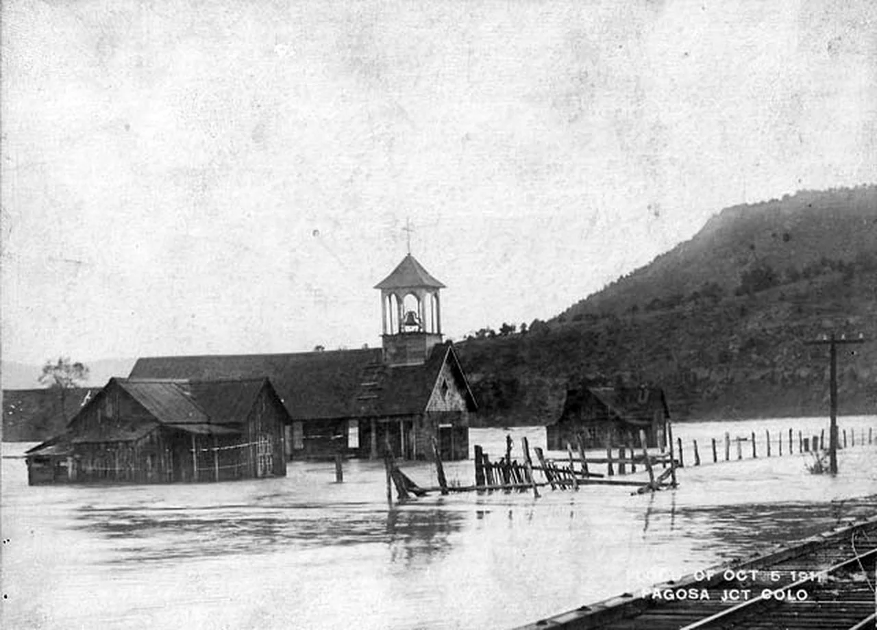
On October 5, 1911, moisture from the Sonora hurricane, a Pacific tropical cyclone, dropped about three and a half to four inches of rain across the region and just over eight inches at Gladstone, near Silverton. The 1911 flood crested at 17.8 feet on the San Juan River, the figure the Sheriff’s Office and the Weather Service still cite as the flood of record. In Pagosa Springs the river swept away more than 20 structures and destroyed the town water plant, the hospital and the jail, according to a contemporary newspaper account quoted by the Land Desk, and the power plant was wiped out of existence, with nothing left but the water wheel. Only three floods before this fall had pushed the river past its 10.5-foot minor flood stage: 1911 at 17.8 feet, 1927 at 13.5 feet, and 2025 at 12.8 feet, according to the Western Water Assessment. The October 2026 crest of 15.02 feet became the second-highest on record. A crest at the forecast levels would be the third major flood in thirteen months, and the first to pass 1911.
“So heartbreaking to see, but Pagosa is resilient,” Maria J. Kelly wrote on Instagram on November 1, posting video of The Springs Resort with the river over its grounds. “They will rebuild and recover, just as they always have.” Her caption said the resort was evacuated as crews prepared for an expected 22-foot crest, seven feet higher than the previous week’s flooding. On October 23, Michele Sharpy had posted two photographs of the flooded downtown on Threads with the words, “My new home, my sweet mountain town, Pagosa Springs, is flooded. I’m safe. Just weary. Friends are evacuated. Here’s our downtown.” Against the official figures, which moved from 9.51 feet to more than 21 feet in three days, the two posts held to fixed measures: the height above the last flood, and the weariness of a second evacuation. Vicki Shaffer of the Sheriff’s Office told residents that help might not be immediately available during Sunday evening and Monday morning.
The town’s sewage notice, posted at 11:45 a.m. on Sunday, said sewage was being discharged into the San Juan River near the First Street Bridge and told residents to avoid all contact with the river water, including downstream. The sanitation district advised that the sewer system was already operating at reduced capacity after the previous flooding and could be further damaged. The shelter at the Pagosa Lakes Property Owners Association clubhouse, at 230 Port Avenue, was open. Small animals were to be taken to the Humane Society on Cloman Boulevard, and large animals to the Archuleta County Fairgrounds on Highway 84.